
Fascinating Tidbits About Otherworldly Wonders Of The World
Earth is home to all of our possessions and memories, and it is also full of breathtaking vistas, animals, plants, and scenery to keep us amazed. There are more fantastic and lovely things on this planet than any one person can see in their lifetime. There are also a massive number of riddles still to be solved. For example, over 80% of the ocean still remains unexplored! One can only wonder what lurks in the mysterious waters. Perhaps Ariel really is swimming around in there.
Given the sheer scale of everything available on Earth, it makes sense that one would want to learn about everything the natural world has to offer. The innumerable amount of discoveries that happen daily is a testament to just how fascinating learning about the planet we inhabit is. So, sit back, relax, and scroll through these images that pay tribute to the wonders of our world.
Many possibilities
Sadly, the residents of a hilariously named village in Austria have decided to change its name. For those curious, it’s pronounced “foock-eeng”—like someone saying the curse word with an accent. They have changed it to Fugging after giving birth to centuries worth of raunchy jokes. It’ll be sorely missed.
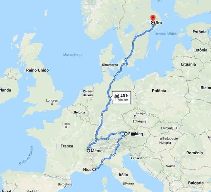
The other geographical names in the map above are also quite unusual. There is “Nice” in France, “Meme” in Switzerland, and Bro” in Sweden. If there is a naming committee for these sorts of things, then they definitely have a sense of humor.
Empire state of mind, indeed!
New York is the nation’s most populous city, with 8,550,405 residents as of 2022. This is more than twice the population of Los Angeles, which is ranked second. In fact, New York City is the home of around one out of every 38 US citizens.
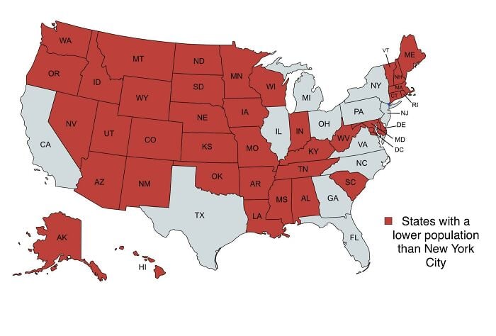
With almost 27,000 individuals per square mile, New York City also has one of the highest population densities out of any major American metropolis. Over three million people call New York City home; more than one-fourth were born overseas and immigrated in the year 2000 or later.
Ho-Ho-home of Santa
Why would Father Christmas reside and operate at the harsh and distant North Pole when he has the choice to pick any other location across the globe? The answer is this: Thomas Nast created a famous advertisement for Harper’s Weekly in 1863 that featured Santa Claus bringing presents to Union Army troops.
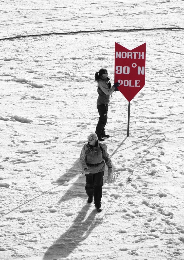
Nast continued to create annual Christmas illustrations, one of which showed a letter to Santa Claus addressed to the North Pole. There you go—one cartoonist’s imagination was powerful enough to change the perception of generations of young children to come.
Traverse Europe within a day!
What do Poland, Paris, London, and Banana have in common? They’re all villages in Kiribati. Why are they named after countries, you ask? Well, firstly, a Polish adventurer and engineer helped the people of Kiribati create a new irrigation system. The village is named Poland in his honor.
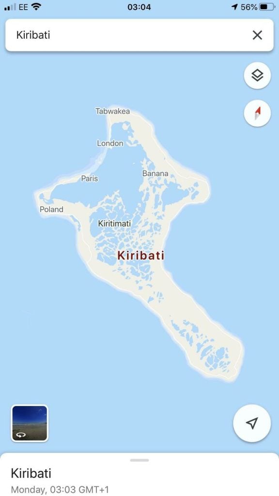
A French missionary rented the island and cultivated around 800,000 coconut trees. He lived in the village of Paris (again, named in his honor). The reason for the name of London could be due to the British occupation. And Banana…perhaps someone liked bananas.
Sail from Chile to Spain
So, you’re bored, you are well off, and you have some boating experience; maybe you take your kayak to the Potomac on the weekends. You go on holiday to Spain. Then, an idea strikes you. If you can pull it off, you will become a legend.
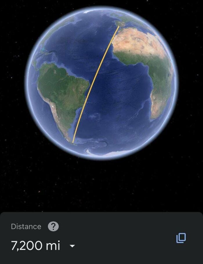
Why not sail from Spain to Chile in South America? It is pretty much a straight line, and these days, boats practically navigate themselves, right? What can possibly go wrong? As wild as this sounds, this is something people actually do!
Hout Bay, Western Cape, South Africa
Imagine a former fishing village by the ocean, with luxuriant green trees and the majestic Cape Mountains towering in the background. The very first Dutch governor, a nobleman by the name of Jan van Riebeeck, gave the region the moniker Hout Bay in 1652.
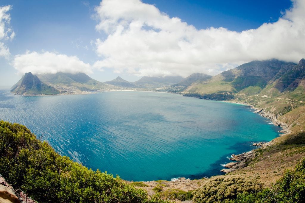
On their voyage to India, the Dutch first inhabited the Cape in the 17th century. The title translates directly to “Wood Bay,” as seen by the numerous, still-existing, beautiful green trees. Words can’t properly describe how beautiful this looks on a sunny day.
Mission accomplished
Remember the Four Corners Monument from Breaking Bad? Arizona, New Mexico, Utah, and Colorado converge at this special memorial, the only location of its kind in the United States. Put a limb in each location, and you’ve accomplished your goal of visiting all four states.
The memorial, which is under the management of the Navajo National Department of Park and Recreation, is a beautiful location for pictures, but it can be difficult to get there. This alternative isn’t four corners per se, but it still manages to cover 5 states! Impressive.
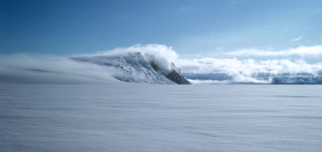
Antarctica means “opposite to the Arctic.”
Despite being separate from the other landmasses, Antarctica is linked to the remainder of the world by both oceanic and atmospheric currents. The Southern Ocean, which surrounds the continent of Antarctica, is a major influence on the planet’s marine and atmospheric ecosystems.
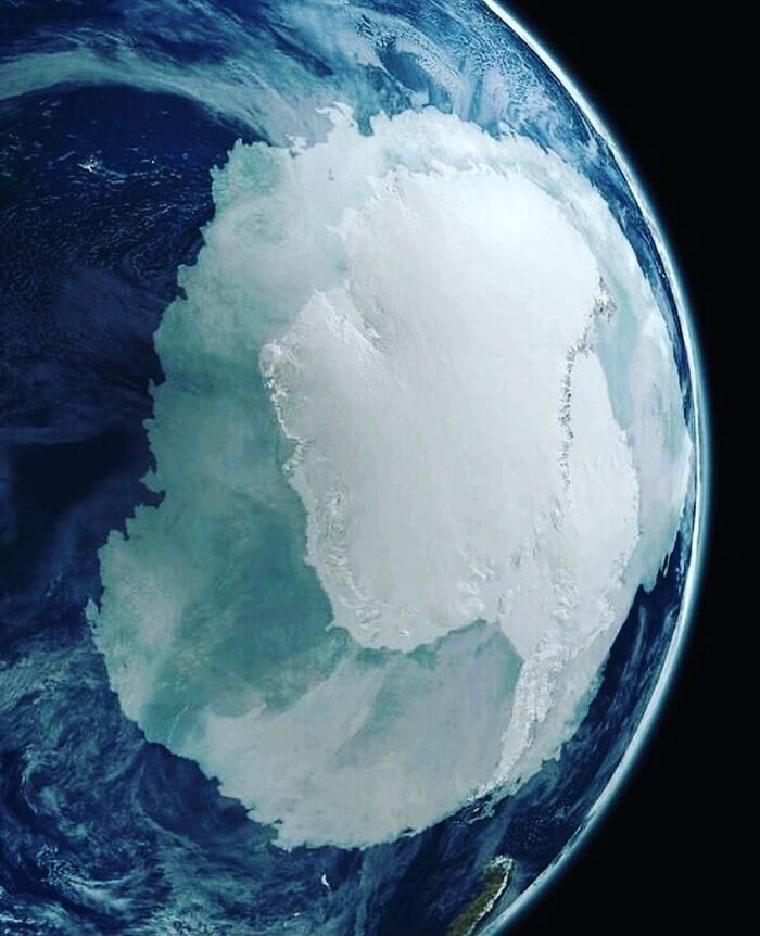
About 90% of the ice on Earth is located here, and 70% of all freshwater on Earth is trapped inside the Antarctic ice sheet. If Antarctica was to melt entirely, there would be a 58-meter (about 190-foot) rise in the global sea level.
La Serenissima
As beautiful as Venice, Italy is at ground level, when seen from above, it looks like a big fish swallowing a smaller one. We wonder if that is a coincidence or if the city planners have an active imagination. The city’s old graveyard happens to be the rectangular island on the left.
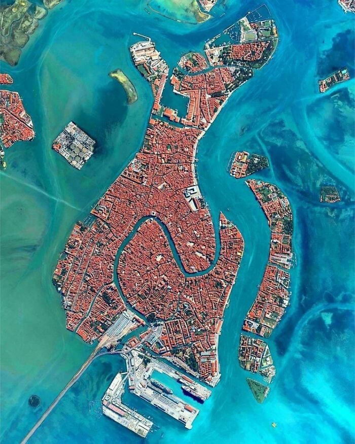
This is where Igor Stravinsky, Ezra Pound as well as other artists are buried. The famed glassmaker’s island, Murano—in which Venetian glass manufacturers were relocated in 1290 after a spate of fires that decimated the town—is just barely visible on the far-left corner.
Horseshoe Bend, Arizona
Around two hundred million years ago, a massive collection of dunes stretching from Arizona to Wyoming blanketed the United States, forming the region known today as Horseshoe Bend. Geologists term such regions as “ergs;” the dunes became petrified (turned into stone).
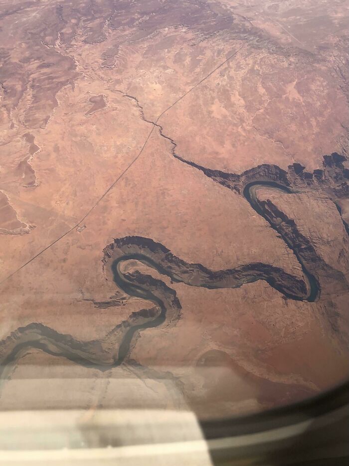
Over time, mineral and water deposits produced a solid, homogeneous slab of sandstone almost 2,000 feet deep in some places. Sedimentary layers settled on top of this reddish Navajo Sandstone’s bedrock after it developed. The picturesque nature of this place warrants a visit.
The border between Idaho and Canada
One of the starkest international borders in the world, visually speaking, is between Canada and the United States. Spanning the Atlantic Ocean to the east and the Pacific Ocean to the WWest, the border stretches 5,525 miles. It passes through villages, glaciers, woodlands, and lakes.
13 American states and eight Canadian provinces border each other. Except in cases of extreme need, a six-foot “no-touching zone” is enforced along the border. This sounds like a rule a mom might impose to keep her kids from fighting in the backseat.
Lost City of Djado, Niger
This city, which was given its contemporary name after the Djado plateau on which it is situated, is of largely unknown origin. However, a number of the buildings appear to be recognizable and reminiscent of other nearby civilizations. How curious.
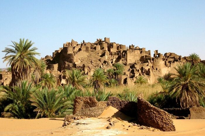
These remains, which date back between 800 and 1000 years, were built when this region of the desert was moist and richly forested. There have been recent discoveries about those who resided in this area, but the buildings still remain largely a mystery.
The Uluru
Ayers Rock is often referred to as the Uluru, which is the term the native Pitjantjatjara Aboriginal people used for it until surveyor William Gosse gave it the title Ayers Rock in 1873 in honor of South Australia Chief Secretary Henry Ayers.
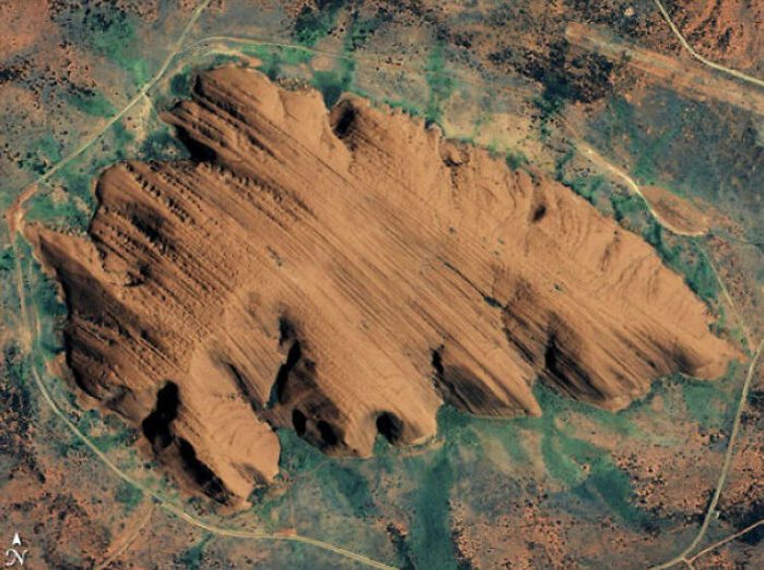
The rock is currently owned and administered by the Aboriginal people, who also urge that outsiders refrain from climbing it because of its religious significance. Seeing the rock’s colors change at sunrise and sunset is a breathtaking experience that should be on any bucket list.
Map of the landlocked countries of the world
Whenever one or more foreign nations encircle another nation on all sides, the encircled nation is “landlocked.” That is, there is no nearby coastline giving the country accessibility to the oceans. There are 44 landlocked nations and five partially-acknowledged landlocked governments in the world.
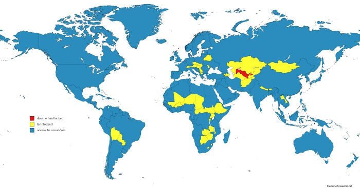
North America, as well as the continent of Australia, are the only continents devoid of any landlocked states. Liechtenstein and Uzbekistan are both landlocked. These are the only two countries that are encircled entirely by other landlocked nations—double landlocked.
Past, present. What of the future?
Numerous Native American tribes, such as the Cheyenne, Arapaho, Kiowa, Ute, Navajo, Apache, Shoshone, Comanche, and Pueblo, once called Colorado home. Inside the state of Colorado, only the Southern Ute Tribe and the Mountain Ute Tribe are currently legally registered.
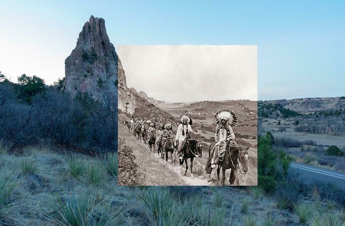
Many cities, towns, and counties around the Centennial State have the names of former Coloradoan tribes and chieftains, such as the City of Pueblo, Arapahoe County, and the Town of Ouray. We don’t know the exact name of the tribe shown here, but the location is in Colorado Springs.
Miccosukee Village
Before Florida became a part of the United States, the Miccosukee Indians lived there as members of the Creek Nation. The majority of the Miccosukee were ethnically cleansed and forcibly relocated to the West by the US during the 1800s Indian Wars, but around 100 of them stayed put.
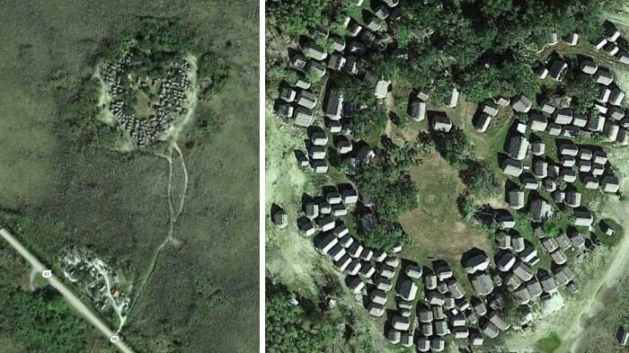
Comprising largely of Creeks who spoke Mikasuki, the stragglers refused to give up their territory and secluded themselves in the Everglades. The current members of the tribe, who total over 600, are descended directly from those who managed to escape captivity.
The red area holds 40% of the Greek population.
Greece’s capital city, Athens, has a population of over 650,000. If one includes Athens’ larger urban region, that number rises to over three million. The city, which is also the southernmost capital of the European peninsula, is a substantial economic hub in southeastern Europe.
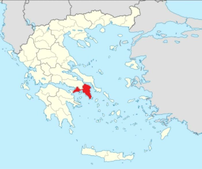
Thessaloniki is the second-largest city in Greece, and its metropolitan area is home to over a million people. Due to its well-known events and a broad array of cultural activities, it is recognized as the cultural center of Greece. No wonder the population is dense in these areas.
We need a new perspective.
Our use of the same world map since kindergarten is pretty weird when you think about it. There isn’t really a “standard” way to look at the world; we’ve invented that. Even though the Mercator projection map is indeed the most commonly used, it is horribly inaccurate.
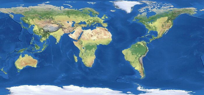
Given that it is impossible to flatten the world (a rough sphere) accurately into a two-dimensional rectangle, regions including Greenland, Antarctica, and Africa are all seriously distorted on classic Mercator projections. Seeing the entire Mercator map of the world backward reveals the extent that the proportions are off.
Quebecois loves a dip.
Residents in several Quebec suburbs simply need to glance over the fence to confirm this next fact: A neighboring backyard pool is typically the norm for them. The prevalence of backyard swimming pools is unparalleled outside of Quebec. Why vacay when you can stay-cay?
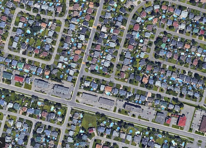
The closest areas of comparison are the hottest regions of the southern United States, but then even California does not really compare to the province in terms of pool coverage. Quebecois have historically tended to remain indoors more frequently than most throughout their brief, hot and humid summers.
Pluto is smaller than Russia. In Moscow, Putin smiles.
Pluto was recognized as the solar system’s ninth planet for more than 75 years following its identification in the year 1930. It was a far-off and icy oddity, to be sure, but it was still a part of Earth’s close family.
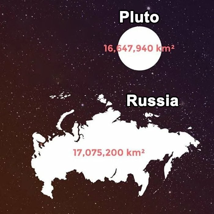
In 2006, Pluto was reclassified by the International Astronomical Union (IAU) as a “dwarf planet,” a newly established classification that was made to distinguish Pluto from the other eight “real” planets. Don’t worry, Pluto; you will always be a real planet to us!
Borders among Nepal, India, and Bangladesh
Mountain ranges, river systems, oceans, waterfalls, and plains are examples of natural boundaries. Natural barriers can occasionally create borders between nations or governments. Landscape borders are artificial rather than natural; however, they can nevertheless take the appearance of peaks, lakes, and woods.
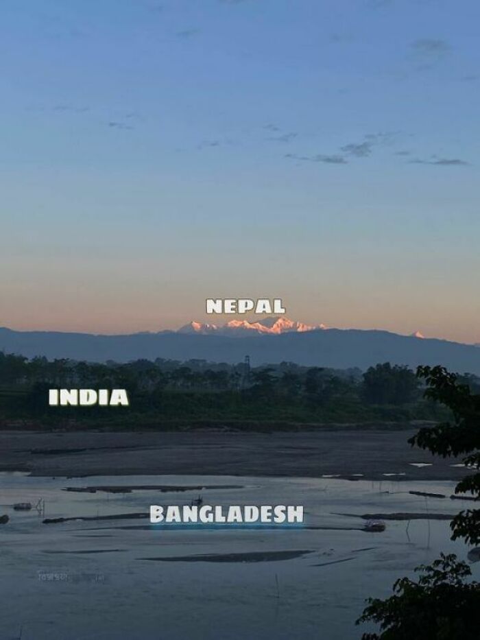
Altering the natural geography of the border region, establishing a landscape border (which is typically done to demarcate treaty-designated political boundaries between nations) artificially reshapes nature. Natural borders have historically been advantageous from a strategic standpoint due to their simplicity of defense.
Alien landscape?
This is a beautiful example of something called fingering instability (or Staffman-Taylor instability). It happens with two immiscible fluids (they don’t mix, like water and oil) when the less viscous displaces the other one. This phenomenon is common in drainage in soils.
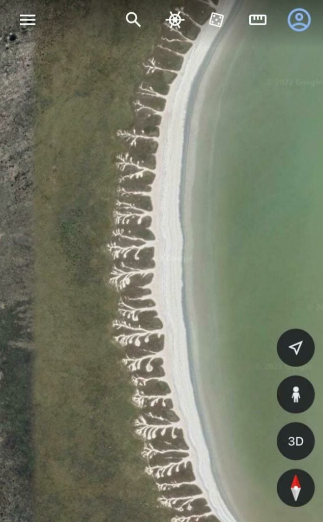
Here, the less viscous water slowly displaces the more viscous soil, in this case, sand. The tree branch-like impressions seem to have a name as well. They are called Lichtenberg figures, which is also the name for the designs you get when you send an electric current through a piece of wood.
The power of the kings, so to speak.
The global language in business, trade, academia, and numerous other important fields is English. Even within diplomacy, where the French language historically had dominance, English now predominates in the majority of the world’s areas. The French are not going to like that little tidbit!
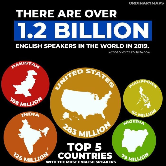
Such is the view, according to eminent linguist David Crystal, that the British Empire’s growth was one of the primary military and political causes that contributed to English “power.” Later, English’s impact was further expanded by its role as the vernacular of the scientific, industrial, financial, and economic revolutions.
Spread of towns called Torre, in Italy
Torre is the Italian word for “tower.” Seems like we are stating the obvious, but this might explain why most of the towns named Torre have a tower. This sounds like a nightmare to navigate! How do you know which Torre is the correct Torre?
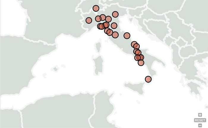
Another theory has to do with the existence of fortresses and defensive structures. Due to frequent invasions by north African pirates during the medieval ages, it was customary practice to construct observation towers, which were occasionally named after neighboring villages along the coastlines.
Mount Fuji is breathtaking from all angles.
Mount Fuji is actually a composite volcano that grew bigger as lava and ash accumulated on its summit. Fuji is Japan’s tallest mountain, standing at 12,388 feet. Its beautiful volcanic conical form, which many compare to an overturned fan, makes it distinctive and highly valued for its aesthetics.
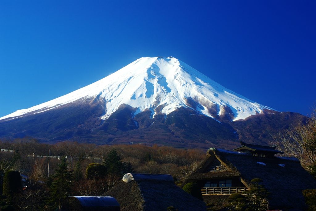
Shinto and Buddhism, the two main faiths of Japan, both hold Fuji in high respect. Contrary to numerous other holy peaks, those religions mandate that Fuji be scaled, and each year, tens of thousands of visitors and devout believers alike ascend Mount Fuji.
Cultural zones of the United States of America
The United States is a very diversified multicultural nation. In his work “American Nations: A History of the Eleven Rival Regional Cultures of North America,” Colin Woodward makes the claim that the United States is really 11 distinct nations, split across clear cultural divides that date all the way to the 16th century.
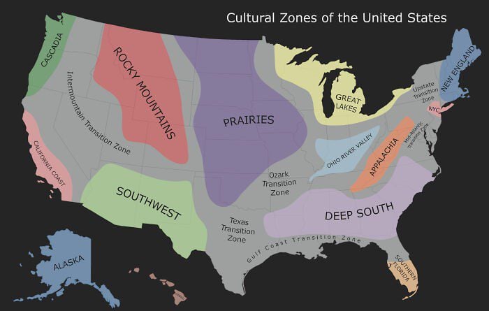
In this map here, though, we can see some other areas as well, namely the Pacific Southwest, Cascadia, California coast, Rocky Mountains, Prairies, Great Lakes, the Deep South, Ohio River Valley, Appalachia, Southern Florida, New York, and the transition zones among them.
Spot the similarities!
Venezuela is 1,297 percent bigger than Lithuania. There are 2.7 million people living in Lithuania—25.9 million more people live in Venezuela. However, when you scale the countries so that they are geographically the same size, the shape looks quite similar.
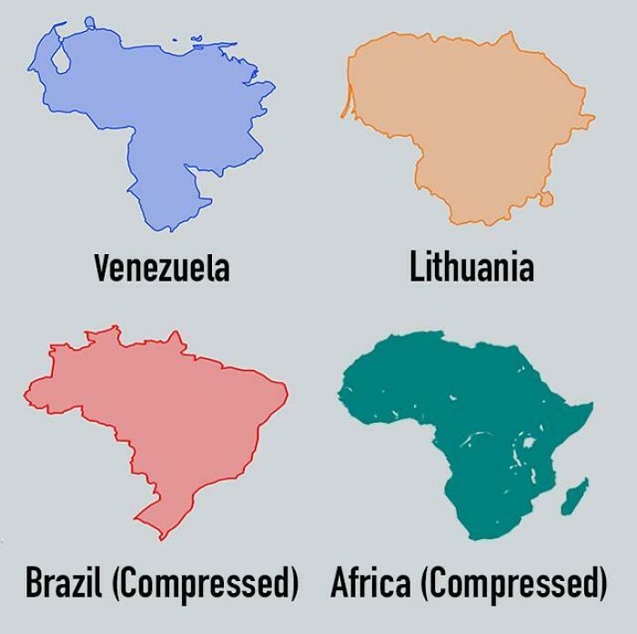
There might be a slight similarity when it comes to the overall shape, but that is where the purported similarity meets its end. The difference in size is just staggering. Same thing when comparing Brazil with the continent of Africa. Mind you, there are people who refer to Africa as a country!
Toblerone ftw!
The logo for Toblerone has more than just mountains. In fact, the artwork skillfully conceals a bear. It pays homage to Bern, the Swiss city where the chocolate business was established. Bern’s coat of arms features what appears to be a bear rising skyward.
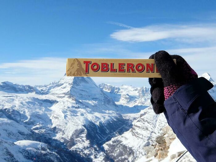
That earned Bern the moniker “The City of Bears.” Did you notice the image of the Matterhorn on the Toblerone’s packaging while savoring it? The Swiss Alps cliff, which is a prominent natural formation of Switzerland, is artistically portrayed in the Toblerone emblem.
How punny!
Well over 3,100 kilometers of Chile’s coastline runs along the South Pacific Ocean. Imagine it as a long, vibrant streamer or chili pepper teasing the ocean on South America’s hemline. In actuality, the Andes mountainous region extends the entire extent of Chile.
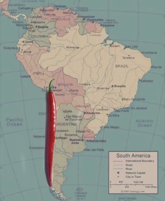
This makes Chile the longest nation in the world, spanning north to south. The indigenous Mapuche term “chilli,” which means “where the land ends,” is considered one of the many etymological sources. It might also be modeled after the Mapuche’s rendition of the bird call, “cheele cheele.”
Hrafna-Flóki pulled a little sneaky.
According to legend, a Norwegian named Hrafna-Flóki Vilgerarson gave Iceland its name. According to Landnáma, which means “The Book of Settlements,” Hrafna-Flóki traveled from Norway to Iceland alongside his family and livestock in order to establish a new life. All the livestock perished in Iceland’s first winter.
That incident led him to decide to depart the country. Before leaving, he noticed that the Vatnsfjörur fjord appeared to be completely covered in ice, which led him to give the location the name Iceland. Later, Vilgerarson came back to Iceland, and this time he settled down permanently.